Aquifers Explained: Which Rocks Hold Water?
The single biggest factor in whether your well succeeds isn't luck, the driller, or the season – it's the rock. This short course in practical hydrogeology, based on university lecture notes (Radulović, 2026), explains what an aquifer really is, why some ground yields abundant water and some almost none, and how to recognise which kind you're standing on.
An aquifer is a sponge, not a lake
A common mental image of groundwater is an underground lake or river. In reality, an aquifer is a saturated, permeable geological unit able to transmit significant quantities of water under ordinary hydraulic gradients (Freeze & Cherry, 1979, cited in Radulović, 2026). The water fills the pores between sand grains, the cracks in fractured rock, or dissolved channels in limestone. Its opposite is an aquitard or aquiclude – layers such as clay or solid marl that transmit water far more poorly and act as barriers (Radulović, 2026).
The three types of porosity
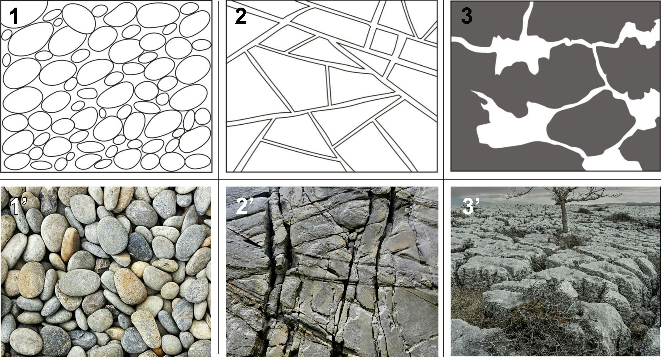
How water sits in and moves through the ground depends on the type of void space (Radulović, 2026):
- Intergranular porosity – pores between grains of gravel, sand or silt. These aquifers (river plains, old lake beds) are predictable and easy to develop: wells almost anywhere in them find water. The finer the grains, the more water is held but the more slowly it flows – clay is porous yet practically impermeable.
- Fracture porosity – water lives in the cracks of otherwise solid rock (granite, gneiss, sandstone, flysch). Yields depend on hitting water-bearing fracture zones, so siting matters much more.
- Karstic (cavernous) porosity – in limestone and dolomite, flowing water dissolves fractures into channels and caves. Karst aquifers can be spectacularly productive (they feed the largest springs on Earth) but are the least uniform: one borehole can strike an underground stream while another 50 m away stays dry.
How much water do rocks actually hold?
Orientation values of porosity (Heath, 1987, cited in Radulović, 2026): soil ~55%, clay ~50%, sand ~25%, gravel ~20%, limestone, sandstone and basalt ~10%. Note the trap: clay has high porosity but its microscopic pores hold water so tightly that it yields almost nothing to a well. What matters for wells is effective porosity – the share of water free to drain – and permeability, the ease of flow (Radulović, 2026). Gravel wins both; clay loses both.
Unconfined vs confined (artesian) aquifers
Aquifers whose upper surface is a free water table are unconfined – most shallow dug wells tap these. Where a permeable layer lies sandwiched beneath an impermeable cover, the aquifer is confined and its water is under pressure: drill through the cover and the water rises in the well above the top of the aquifer, occasionally flowing at the surface without a pump – an artesian well (Radulović, 2026). Confined aquifers are often deeper but better protected from surface pollution.
What this means for your well
| Your ground | Prospects |
|---|---|
| River valley, plain (sand/gravel) | Excellent – shallow, reliable, easy to dig or drill; see dug vs drilled wells. |
| Sandstone hills | Good – moderate, steady yields from pores + fractures. |
| Limestone / karst | Potentially superb, but variable – siting is critical; expert data pays off most here. |
| Granite, gneiss, schist | Modest – target fracture zones; deeper drilling, lower yields. |
| Thick clay | Poor – look for sand lenses within it, or drill through to what lies beneath. |
wheretodigwell.com reads the geology for you: click any point on the map and get a free estimate of the depth to groundwater – based on global geological, terrain and climate data. Unlock a location to see its drilling suitability and expected well yield, with the detailed AI report included, from $9.80.
Check your geology free →
Frequently asked questions
What is an aquifer in simple terms?
A saturated, permeable body of sediment or rock – a water-soaked sponge of sand, gravel or fractured rock that can feed wells and springs. Not an underground lake.
Which rocks make the best aquifers?
Sands and gravels are the most reliable; karstified limestone can be the most productive; clay and unfractured crystalline rock are the poorest.
Confined vs unconfined – what's the difference?
Unconfined aquifers have a free water table; confined aquifers sit under an impermeable lid and are pressurised, so well water rises above the aquifer – sometimes to the surface (artesian).
Next: how deep is the water table · how much water will your well produce · the complete siting guide
References:
Freeze R.A., Cherry J.A. (1979). Groundwater. Prentice-Hall, New Jersey, 604 p.
Radulović M.M. (2026). Hidraulika podzemnih voda – izvod iz predavanja (Groundwater Hydraulics – Lecture Notes). University of Montenegro, Faculty of Civil Engineering, Podgorica.
Radulović Đ.M. (2003). Osnovi geologije (Fundamentals of Geology). University of Montenegro, Faculty of Civil Engineering, Podgorica, 234 p.
Note: Estimates from wheretodigwell.com are a preliminary, data-based screening tool, not a guarantee of groundwater conditions at any specific site. Actual depth, yield and water quality can only be confirmed by drilling and testing, and local conditions may differ from regional data. Always check local regulations before constructing a well.