How Deep Is the Water Table on My Land?
"How deep will I have to dig before I hit water?" is the single most important – and most expensive – question in any well project. Depth determines whether you can dig by hand or must hire a drilling rig, how powerful a pump you need, and ultimately what the well will cost. Here is what actually controls that depth, and how to find it out for your land without drilling a test hole.
What the water table actually is
Rain and snowmelt that infiltrate the ground move downward through soil and rock whose pores contain both air and water – the unsaturated zone. At some depth, every pore and fracture becomes completely filled with water: this is the saturated zone, or aquifer, and its upper surface is the water table (Radulović, 2026). Dig or drill past the water table and water will stand in your well; stop short of it and the hole stays dry.
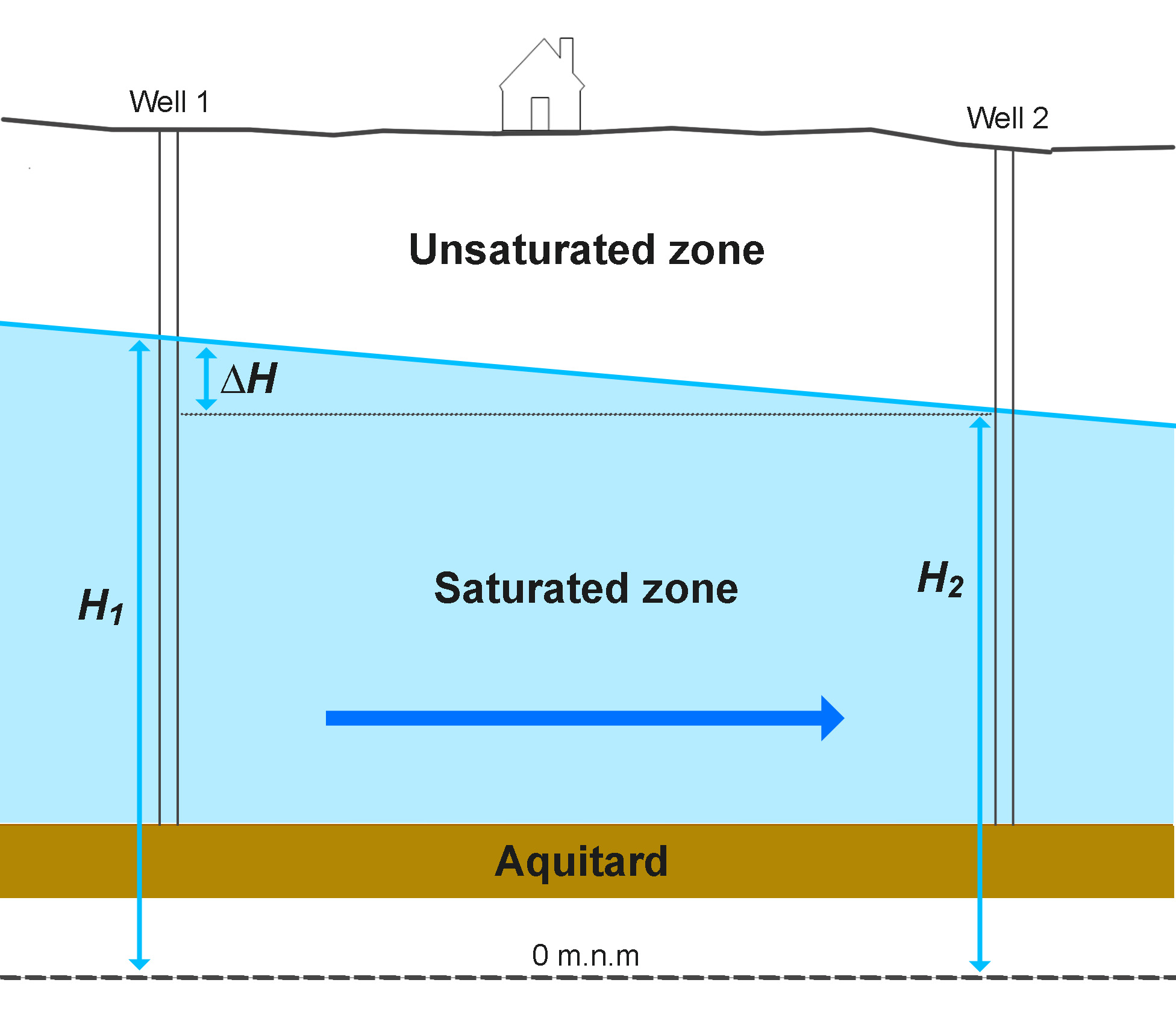
Two details matter for well planning. First, the water table is not flat: it slopes, broadly following a gentler version of the land surface, and groundwater flows down that slope from points of higher water level toward lower ones (Radulović, 2026). Second, in some places a permeable layer is sandwiched beneath an impermeable one – a confined (artesian) aquifer – and water in a well drilled into it rises above the layer it came from, occasionally all the way to the surface.
What controls the depth to groundwater
| Factor | Effect on depth |
|---|---|
| Topography | Shallow in valleys and plains, deep under hills, ridges and plateaus. Rivers and lakes are places where the water table meets the surface. |
| Climate | Humid regions recharge aquifers constantly → shallower water table. Arid regions → deeper, sometimes hundreds of metres. |
| Geology | Highly permeable rocks (gravel, karstified limestone) drain quickly toward rivers and springs, which can keep the water table deep on high ground; low-permeability layers can hold "perched" water close to the surface. |
| Season | The water table rises in the wet season and falls through the dry season – the swing ranges from under a metre in stable plains aquifers to 10+ metres in karst (Radulović, 2026). |
| Pumping nearby | Heavy extraction (irrigation, municipal wellfields) lowers the water table across whole areas. |
Typical depths – and why averages mislead
Globally, hand-dug wells historically reached water at 3–15 m in valley settlements – because settlements grew where water was shallow. Drilled household wells are commonly 30–100 m; in arid zones or on elevated karst plateaus, productive boreholes may need to go several hundred metres. But regional averages are nearly useless for a specific parcel: two properties a kilometre apart can differ by tens of metres depending on elevation and geology. You need a point estimate, not an average.
wheretodigwell.com gives a worldwide, science-based first estimate of the depth to the water table for any point you click, plus the expected well yield and drilling prospects. A detailed AI report from $9.80 adds local geology, recommended drilling depth and risks.
Get your free estimate →
Plan for the dry season, not the wet one
A classic mistake: digging a well in spring, finding water at 4 m, stopping at 5 m – and watching the well go dry in August. Aquifer levels fall through the dry season as discharge to springs and rivers continues while recharge stops (Radulović, 2026). Always design well depth against the lowest expected water level, and add a safety margin below it so the pump stays submerged. Professional practice is to test wells at the driest time of year for exactly this reason.
Other ways to establish local depth
Ask neighbours with wells for their depth and static water level – the single best local data source. National geological surveys publish borehole databases in many countries. Observing where springs emerge and where streams keep flowing in drought also brackets the water table elevation. Combine any of these with a map-based estimate to greatly reduce the chance of an expensive surprise.
Frequently asked questions
How deep do I have to dig to reach water?
Anywhere from ~2 m (river valleys) to hundreds of metres (arid plateaus). It's a location-specific answer – get it free for your parcel at wheretodigwell.com.
Does the water table change during the year?
Yes – it rises in the wet season and falls in the dry season. Size your well for the late-dry-season minimum.
Is the water table flat?
No, it slopes with the terrain, and groundwater flows along the slope. That's why depth to water differs even between neighbouring parcels.
Next: how to choose where to dig a well · dug vs drilled wells · how much water your well will produce
Reference: Radulović M.M. (2026). Hidraulika podzemnih voda – izvod iz predavanja (Groundwater Hydraulics – Lecture Notes). University of Montenegro, Faculty of Civil Engineering, Podgorica.
Note: Estimates from wheretodigwell.com are a preliminary, data-based screening tool, not a guarantee of groundwater conditions at any specific site. Actual depth, yield and water quality can only be confirmed by drilling and testing, and local conditions may differ from regional data. Always check local regulations before constructing a well.