Before You Drill a Water Well, Read This First
A hydrogeology-based digital assessment can help reduce uncertainty before drilling — at a fraction of the cost of traditional investigations.
Every summer, thousands of landowners, farmers, ranchers, irrigation managers and drilling contractors invest in new water wells. For many, a reliable groundwater supply is essential for crop irrigation, livestock, rural homes or commercial operations. Unfortunately, drilling a successful well is never guaranteed.
A single unsuccessful borehole can cost anywhere from several thousand to tens of thousands, depending on local drilling conditions. Even more frustrating, a well that reaches groundwater is not necessarily a productive one — some wells produce only a few litres per minute, far below what is needed for irrigation or continuous supply. The question is simple: can you reduce the risk before drilling begins?
Advances in digital terrain analysis, satellite-derived environmental datasets and hydrogeological modelling now make it possible to perform an initial assessment long before heavy drilling equipment arrives on site. It is not a replacement for professional hydrogeological investigations — but it can provide valuable guidance before committing significant money to drilling.
Why do water wells sometimes fail?
Many people assume that groundwater exists at roughly the same depth across an entire area. Hydrogeologists know this is rarely true. Groundwater occurs within geological formations known as aquifers, but their depth, thickness and productivity depend on many interacting factors, including local topography, geological structure, rock permeability, fracture systems, karst development, drainage patterns, climate and groundwater recharge.
Two wells located only a short distance apart may encounter completely different conditions. One may produce abundant groundwater for decades; the other may remain almost dry. That is why choosing where to drill can be just as important as deciding how deep.
Why depth alone is not enough
One of the most common misconceptions is that reaching groundwater automatically guarantees a successful well. In reality, groundwater level and well productivity are two very different things. A shallow water table does not necessarily indicate a productive aquifer, and groundwater at greater depth may sit within highly permeable formations capable of producing large volumes.
Professional hydrogeologists evaluate much more than depth — geological formations, expected aquifer properties, groundwater flow, recharge potential, geomorphology, nearby rivers and lakes, structural geology and climate, among other factors. This comprehensive assessment is precisely why professional investigations remain the most reliable approach. They are, however, expensive — often several thousand — which for many individual landowners is not practical before deciding whether a property is even worth drilling.
Understanding why wells differ
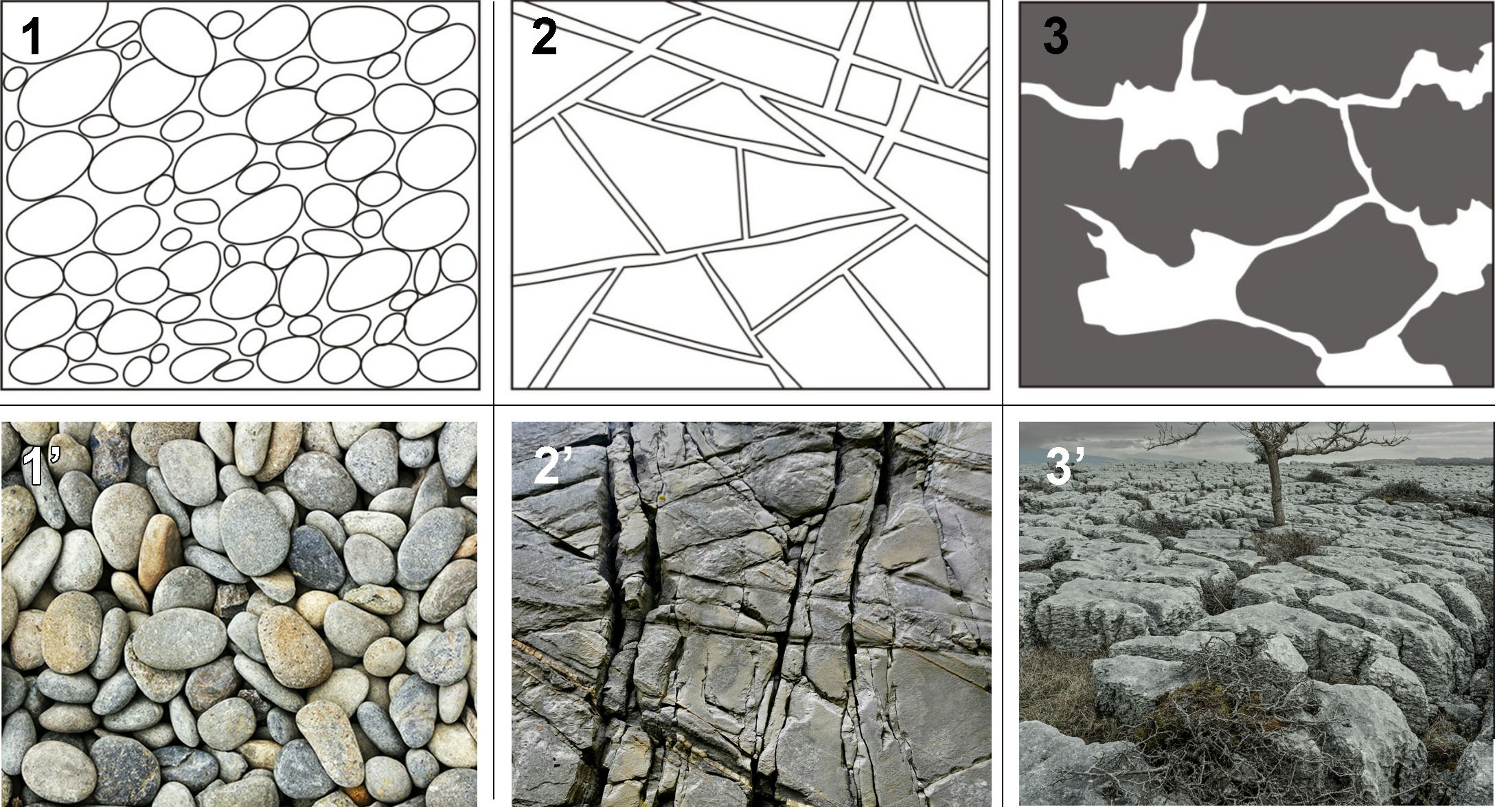
Different geological formations store and transmit groundwater in very different ways. Some aquifers consist of sands and gravels where water flows through pore spaces between grains. Others depend on fractures within hard rock. Karst aquifers may contain large dissolution channels capable of exceptionally high yields, but can also be highly unpredictable. These differences explain why two wells drilled at similar depths may produce dramatically different amounts of water.
A new generation of hydrogeological decision support
Recent advances in geospatial technology make it possible to perform an initial hydrogeological assessment using globally available environmental datasets. High-resolution digital terrain models, satellite-derived information, hydrographic networks and geological datasets now provide valuable insights into groundwater-related conditions over large areas. Instead of relying on a single parameter, modern models combine multiple environmental indicators to estimate groundwater conditions and evaluate the likelihood of obtaining a productive well.
Importantly, these are decision-support tools. They reduce uncertainty; they do not eliminate it. Even the best digital assessment cannot detect every local geological anomaly or replace field investigations carried out by experienced hydrogeologists.
A practical example — wheretodigwell.com
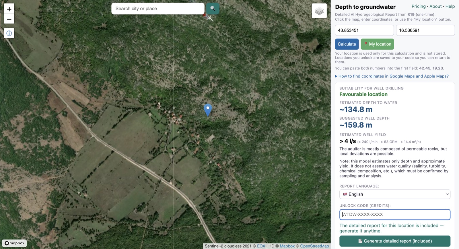
One example of this new generation of tools is wheretodigwell.com, an online application developed to provide a rapid preliminary assessment before drilling. Rather than asking users to purchase a report immediately, the platform offers unlimited free estimates of groundwater depth — you simply click anywhere on the interactive map to obtain an estimated groundwater level for that location. Those who need a more comprehensive assessment can unlock a detailed report that also evaluates expected drilling potential, estimated well productivity, local geological context and additional hydrogeological considerations.
The system combines a proprietary hydrogeological model with multiple environmental datasets. Artificial intelligence is used only in the final stage — not to "guess" groundwater, but to interpret model outputs, incorporate optional information provided by the user, summarise relevant publicly available information about the local area and generate a structured report in plain language. The scientific assessment comes first; the AI helps explain the results.
Can you trust digital models?
This is probably the most important question, and the honest answer is: sometimes they perform remarkably well, and sometimes they do not. Hydrogeological conditions vary enormously around the world. In areas where measured groundwater levels and pumping-test results are available, comparisons show encouraging agreement with the digital estimates. In regions characterised by highly complex geology, intense faulting or heterogeneous aquifers, deviations may occur. No responsible hydrogeologist should promise perfect accuracy — a digital assessment is best viewed as an additional source of information that helps guide better decisions.
A simple way to evaluate reliability
Before relying on results for your own property, compare the model against several nearby locations whose groundwater depth or productivity is already known — productive wells, dry wells, neighbours' wells, municipal records, and publicly available groundwater and drilling data. If the estimates reasonably match local reality, confidence increases. This simple verification step often provides far more insight than judging a model in isolation, and it is the best way to gauge accuracy for your area, where local geology may differ from regional data.
What this tool can — and cannot — do
It can help you estimate groundwater depth, assess drilling potential, estimate expected well productivity, obtain a structured hydrogeological assessment, generate an AI-assisted report incorporating your observations and local public information, and reduce uncertainty before investing in drilling.
It cannot guarantee groundwater will be found, guarantee a productive well, replace licensed hydrogeologists, replace field investigations, drilling or pumping tests, detect every local geological anomaly, or eliminate drilling risk.
A smarter first step
For many projects, the decision is not whether to perform detailed hydrogeological investigations, but whether they are justified before spending thousands. A fast digital assessment costing about $9.80 can often help identify promising locations, raise important questions and reveal situations where additional professional investigations are advisable — which alone may prevent expensive mistakes. If the assessment suggests favourable conditions, the next step may be a professional investigation or exploratory drilling; if it indicates significant uncertainty, it may save substantial time and money by encouraging further evaluation before drilling begins. Either outcome provides value.
Final thoughts
Groundwater will always involve uncertainty — nature is more complex than any model. Yet today's hydrogeological tools are increasingly capable of transforming vast amounts of environmental information into practical guidance for landowners, farmers, drilling contractors and irrigation professionals. Used responsibly, they are not a substitute for science — they are an extension of it. Before investing thousands in your next well, taking a few minutes to perform an initial digital assessment may be one of the smartest decisions you make.
Estimate groundwater depth at any location worldwide, free. Need more? Unlock a location for its drilling suitability, expected yield and a detailed AI report — from $9.80.
Check your location free →
References
Radulović M.M. (2026). Hidraulika podzemnih voda – izvod iz predavanja (Groundwater Hydraulics – Lecture Notes). University of Montenegro, Faculty of Civil Engineering, Podgorica.
Radulović Đ.M. (2003). Osnovi geologije (Fundamentals of Geology). University of Montenegro, Faculty of Civil Engineering, Podgorica, 234 p.
Estimates from wheretodigwell.com are a preliminary, data-based screening tool, not a guarantee of groundwater conditions at any specific site. Actual depth, yield and water quality can only be confirmed by drilling and testing, and local conditions may differ from regional data. Always check local regulations before constructing a well. See the methodology & validation.